|
|
At Schlencker Mapping, we continually invest in new technologies that increase the value of our services for our customers. We are always seeking new ways to leverage our expertise, technological capabilities, and corporate infrastructure to expand the industries we serve and the services we offer. 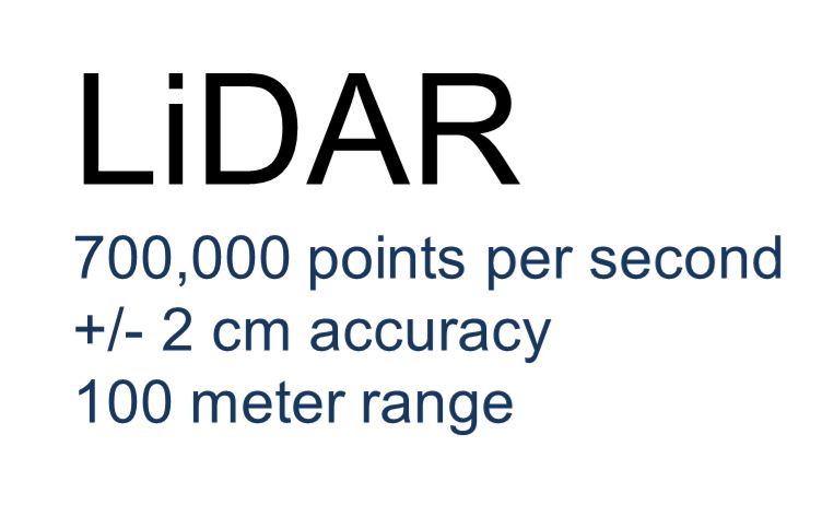  What is Mobile Laser Scanning? Mobile Laser Scanning is a dynamic 3D mapping technology which uses the very latest LiDAR technology, precision navigation and advanced data processing coupled with innovative system design to scan highways, infrastructure, buildings and trees from a moving vehicle. The data collected by Mobile Laser Scanning can be used to create a highly detailed 3D model of street corridors and overhead features, information that can be used for road surface and safety inspections, terrain and industrial asset mapping, bridge height surveys and road width mapping for entire routes. Applications Building Floor Levels: Building floor levels can be measured to assist in flood study analysis and cost-benefit assessments. During capture, imagery is also exposed to allow more detailed feature identification and the collection of additional building attributes. Overhead Line Surveys: At normal driving speeds, Mobile Laser Scanning can detect and map overhead lines. This data can then be used to determine wire heights, wire sag, and clearance of vegetation. Highways, Roads and Railroads: Using the novel Mobile Laser Scanning system combined with video imagery, network assets can be mapped accurately and efficiently. Coastal Surveying: Coastal zones can be mapped for various applications such as erosion and accretion studies, slope and beach level monitoring. Imagery The Mobile Scanning system captures 360° imagery simultaneously with the point cloud. Technology The Optech Maverick is an all-in-one Mobile Mapping System. A single unit comprised of the Velodyne laser, GPS, IMU and Solid State HDD's, all weighs less than 9kg. The system is controlled by Tablet or Smartphone via wifi connection to the Maverick. Due to its ease of mounting the Maverick can be utilised with:
Accuracy Demonstrating proven accuracies, Mobile Laser Scanning uses well-proven laser scanning technology to capture the position of up to 1,000,000 3D points per second, while in motion. The typical positional accuracy of Mobile Laser Scanning is better than 5 cm under good GPS conditions and positional accuracies of 25 mm have been achieved on extracted data with additional ground control points. Deliverables In utilising the latest in LiDAR technology, Mobile Laser Scanning acquires, processes, and delivers data products that meet the diverse needs of clients. The system tends to be easy to mobilize and immediately after the survey, data is processed to provide point data with XYZ position and reflective intensity. Depending upon the customer’s requirements, the data can be processed and analyzed further by:
|
|
| www.schmap.com.au © 2021 |
