|
 The increase in reliability and affordability of digital aerial cameras has seen an increase in demand from end users for digital acquisition. Most digital sensors provide both standard colour (RGB) and Near Infrared (NIR) imagery thus broadening the scope of imagery applications. Digital imagery, and in particular digital orthophoto, allows direct analysis from imagery making it a very valuable and often indispensable layer in GIS. Film is still used extensively in Australia and continues to be a reliable resource for spatial applications. The increase in reliability and affordability of digital aerial cameras has seen an increase in demand from end users for digital acquisition. Most digital sensors provide both standard colour (RGB) and Near Infrared (NIR) imagery thus broadening the scope of imagery applications. Digital imagery, and in particular digital orthophoto, allows direct analysis from imagery making it a very valuable and often indispensable layer in GIS. Film is still used extensively in Australia and continues to be a reliable resource for spatial applications.
Schlencker Mapping is experienced in providing both film and digital imagery and is acknowledged for providing high quality orthophoto products.
What is an Orthophoto?
An Orthophoto or orthorectified image is an image that has been corrected for variations in scale and height displacements so that the resultant image is true to scale in all directions. A printed Orthophoto at a particular scale is as accurate as a map and can be treated the same way. Digitally, the Orthophoto is an intelligent image. Accurate coordinates can be read at any point on the image. For this reason, Orthophotos are a vital layer in GIS analysis and essential for 3D visualisations.
Ortho Generation
Schlencker Mapping uses high quality ortho production software which offers flexible, efficient functionality for producing colour-balanced orthophotos and broad area mosaics. Schlencker Mapping is specialised in providing the following functionality:
- Seamline corrections
- Image balance correction for brightness and contrast variations due to hot spots, vignetting, differences in scanner, quality or settings, different film types, and images acquired at different times of the day or year.
- Colour matching using band ratios, localised corrections and global balancing.
- Pixel void fill.
- Feathering and smoothing operations applied along seamlines.
- Seamline editing.
- True orthophoto (correction for displacements of building and other features not lying on the terrain surface) when required.
|
|
|
|
Our services include:
- Acquisition of film and digital aerial photography
- Film scanning
- Digital orthophoto
- Multi-spectral imagery
- Oblique photography
- 3D visualisation scenes & fly-throughs
|
|
|
|
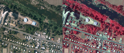
Moreton Bay Regional Council
Digital Orthophoto of the entire Local Government Area. Utilising the Digital Camera to provide 0.15m RGBNIR imagery of urban areas and 0.35m RGBNIR imagery of the rural extents. Completion date – February 2010 More projects>>
|
 +61 7 3256 9955 Contact us for all your Imagery requirements. +61 7 3256 9955 Contact us for all your Imagery requirements.
|